![]()
 | |
|
21 November 2006 Automated surveying
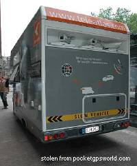
It's essentially a motor caravan with a couple of cameras sticking out the back, a bit like the one pictured here. C-Net has a good description of how they work. (It's particularly interesting to learn from this DigitalTrends story that one of the main uses is mapping lane layouts, something that - as far as I know - the Ordnance Survey doesn't chart.) The People's Republic of MappingAt the same time, there's currently a little bit of low-level chatter about something called, Blair-like, "The People's Map". The project was first described in a Guardian article of November 2nd: "Phillip Tann thinks if the Ordnance Survey won't make its data about roads available for free, he'll generate it - and make that free instead. Next week Dr Tann, who is managing director of Autopoietic Systems Tann Ltd (ASTL), a telemetrics and IT company based in County Durham, will launch The People's Map, inspired by Guardian Technology's Free Our Data campaign. "ASTL provides vehicle tracking systems to companies. "We have 25 vehicles fitted with systems, and we've already mapped out a large part of the road area of the north-east," he says. GPS systems in the vehicles send back details of their location and speed to ASTL's database, which can build up a picture of the road network." But it gets more interesting still. thepeoplesmap.com, .co.uk, and so on are registered to Getmapping. (thepeoplesmap.org appears to be registered to somebody else. ) Getmapping are specialists in aerial photography, of course, but I believe they're also playing around with the New Popular Edition scans which we released into the wild recently. And they have 'previous' with the Ordnance Survey (.DOC press releases here, here.) Phillip Tann's website mostly gives details of ASTL's "vehicle telemetric systems". The page about the People's Map is pretty much empty. There's another interesting snippet on a secondary website which talks about "advanced real-time traffic maps", presumably using data gathered by units like this. But this BCS bio page is the one that intrigues me the most, talking about automated conversion of paper network maps into GIS data. Whether the People's Map is really trying to combine GPS traces, out-of-copyright maps and aerial photography to become "Openstreetmap II" - and who's really involved - I have no idea. It could be vapourware for all we know. (It's a long way from "a large part of the road area of the north-east" to the whole of Britain.) The kitYet the interesting point is how serious surveying technology is becoming ever more affordable. It's not that long since Jo Walsh referred to, in a marvellous phrase, "viably unnecessary, easily outsourceable techno-toys". But when the C-Net story comes to itemise the kit list of a TeleAtlas surveying van, this is all it is: a handful of video cameras, some 3GHz Pentium PCs, a GPS and a hard drive. This is all available off the shelf right now. In a couple of years' time, it will all be in your shiny white mobile phone. The vehicle logging system used by Phillip Tann's company is pretty commonplace, already installed in 1001 fleets across Britain - many owned by companies who'd like to save money on their geodata bills. Openstreetmap has been doing something very similar with London motorcycle courier logs for a while now. Image recognition? Maybe not quite so well advanced at the consumer level - but that's a demand thing, I think, not a feasibility thing. You can take a New Popular Edition map into Photoshop, choose 'Select colours', use the eye-dropper on orange/brown, delete everything else, and you have a rough outline of the roads. Open that in Illustrator, use the tracing tool, and you have some vectors. With a bit of custom programming, you could get human-tidyable results pretty easily. Maybe the People's Map has cracked it already. Maybe one of the big guys is fed up with paying for OS data and has a stealth team of code ninjas working on new automatic recognition techniques (although, of course, it's now been established that the world's greatest concentration of map code ninjas is in Charlbury). But whether they are or not, there are hackers out there right now playing with automatic vectorisation. The Openstreetmap standard for GPS surveying has risen from simple eTrex tracks to every-second NaviGPS logs with photo annotations. Doubtless in a year’s time some early adopter will be doing TeleAtlas-style video surveying for OSM. All of which makes Steve's suggestion that Openstreetmap might map the whole of the UK by 2008 seem less preposterous than it should. As the surveying technology develops, it becomes quicker and easier to map ever greater areas. Every Aberdeen housing estate? Maybe, maybe not. But the equivalent of a road atlas with town plans for all major cities is now almost inevitable. And a ruddy impressive achievement it will be. Of course, we'll still be arguing about licences and what colour the roads should be, but hey, that's volunteer projects for you. CommentsRichard, Posted by Steve Chilton on 21.11.06 15:46 |
SitesGeowiki PeopleEugene Baston ElsewhereBisbrooke Feeds
|
 Driving to