![]()
 | |
|
23 January 2006 Mapping Britain's cycle routesOf late, Anna and I have been taking to our bikes increasingly often.
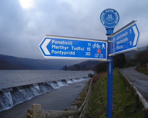
In recent weeks, we've cycled National Cycle Network route 5 from Oxford to Reading, and from Glympton (near Charlbury) to Banbury. Over the border in Wales, we've followed route 8 (aka the Taff Trail) from Cardiff to Talybont-on-Usk; last year, we cycled NCN route 46 from Newport to Blaenavon; and in the spring, I managed the whole of route 8, aka Lon Las Cymru from Cardiff to Holyhead, in four days. The National Cycle Network is a fantastic achievement. Our local rides along route 5 have shown how even the most familiar countryside takes on a new light when you see it from the well-waymarked, quiet back roads which Sustrans have chosen. Between Glympton and Banbury, we found villages we'd never visited; tiny, picturesque country churches; enticing-looking pubs and wonderful, wonderful views. We're now planning our next expedition, which looks likely to be a four-day circuit along routes 4 and 47 between Carmarthen and Fishguard. I love this part of the world, having walked much of the Pembrokeshire Coast Path in that blistering hot summer a few years ago (occasionally aided and abetted by Jo)... while Anna would just like to see the gannets. The National Cycle Network is its own advertising. You'll almost certainly have seen the little blue signs that are sprouting hither and thither, with their red route numbers and directions that seem utterly alien to anyone following Britain's A-road topography. One of the things that got me hooked on it was repeatedly passing signs for route 5, pointing to Stratford, Banbury and Woodstock along roads I'd never consider driving down. I'm now an unpaid NCN evangelist. Unfortunately, it is near impossible to plan an NCN excursion on the Internet. Sustrans are really, really great people (I worked with them a little at Waterscape). The number and quality of place-marker icons on their online maps puts Google and Multimap to shame. They can do more with Mapinfo than anyone in the known world. But, but, but, it's still Mapinfo and commercial GIS packages are completely unsuitable for usable webmapping. (I touched on some of this in my talk to the Society of Cartographers' Summer School last year, which Jo Walsh has very generously blogged today.) We wanted to use the Sustrans map to find how long the route was, so we could plan accommodation; how close to the village of Dale it went (for the gannets); and ultimately, where the route actually goes. It's really, really painful. The best substitute I could find was using Waterscape to look at a Landranger map of Fishguard, then following the route along. I'd love to e-mail Chris at Sustrans and ask for his data, so that I could build a better mousetrap with all of this. (It would be the work of a single day to get the shapefiles and put them in a local copy of the Waterscape mapping system, for example.) But there's no point. I'm 99.2% sure that they were created by tracing along Ordnance Survey maps. That means they're a derived work. That means that, unless I can magic a few thousand pounds out of nowhere for OS licensing fees, I can't do anything with them. This is where the UK is going so, so wrong. Getting more people cycling is a social benefit. It's madness to put obstacles like a shoddy webmapping system in their way. It's much, much deeper madness to prevent anyone else from fixing the situation by imposing unusable restrictions on the required geodata. But that's where we are. (Here's a second example. We wanted to plan our train journeys to and from Carmarthen. Train travel, too, is a social benefit. The official route-planner is pretty poor: we could find neither feasible train times nor affordable tickets. Can I download the raw data to build a better timetable mousetrap? No: that's chargeable, too. So we're driving.)
We are going to get that new mousetrap one day. I just wish it could be a little sooner. (Incidentally, Jo W is too hard on her own talk. I had it easy - talking about whizzy, tangible webmapping systems is always going to be much, much easier to get across than explaining why how and why an abstruse open source model can, and should, work for geodata. In the long term, her talk should be of much more lasting value than mine.) CommentsTotally agree. We cannot afford a copy of Map (e?)Xtreme for our web mapping... and getting data out to the public is a bloody nightmare. Did you work for Waterscape? I like their new on-the-fly PDF canal guides incorporating stoppage info, though it's a tad ropey at the mo. And the GIS Flash client works well, though it's a pity it only works with rasters. Flash rendering of MasterMap would be rather nice... Posted by Tom on 10.2.06 16:59 Mr Chadwin! It has been far, far too long. Yes, most of the Waterscape mapping stuff (Flash / PDF) was my fault. Shall e-mail you separately and wax forth about webmapping and the like. Posted by Richard on 11.2.06 09:49 We're with you ! a few cyclists with a website following the blue signs. cycle-n-sleep.co.uk Posted by steve on 28.9.07 19:21
Posted by Pidcheky on 29.10.07 09:48
Posted by Bbfgobcv on 29.10.07 12:46
Posted by Qiugpfio on 29.10.07 15:27
Posted by Nirawiqg on 29.10.07 18:06
Posted by Nwxwbmux on 29.10.07 20:41
Posted by Nphypzii on 29.10.07 23:20
Posted by Weyaanps on 20.11.07 17:20
Posted by Qtzqyqmy on 20.11.07 20:07
Posted by Emahxvus on 20.11.07 22:56
Posted by Vrjvtttf on 21.11.07 01:44
Posted by Yqzlgsuf on 21.11.07 04:32
Posted by Iuzprzgc on 21.11.07 07:26
Posted by Gdcabtym on 21.11.07 10:21
Posted by Vbjsabjk on 22.11.07 11:04
Posted by Vhoxdvxr on 22.11.07 13:49
Posted by Zkiwzigd on 22.11.07 16:34
Posted by Rpfocoeu on 22.11.07 19:19
Posted by Sqpyhwsf on 22.11.07 22:08
Posted by Cuvscbae on 23.11.07 00:51
Posted by Mwtcyxvq on 23.11.07 03:33
Posted by Pdzzktey on 23.11.07 06:13
Posted by Pdotybjn on 23.11.07 08:57
Posted by Ckcwxukx on 23.11.07 11:37
Posted by Zuloujyc on 23.11.07 14:20
Posted by Bedqywff on 23.11.07 17:00 Hello! Good Site! Thanks you! prpnjlmhepoe Posted by ivzlvjxmcb on 22.1.08 10:33 Hi. This is really interesting post. Thank You! I have just subscribed to Your rss! Best regards Posted by Forexman on 7.6.08 16:13 I don't suppose there is a cycle path from Bath down to the dorset coast, I just Can't seem to find a map anywhere Posted by Michael on 8.7.08 22:27 | |
 When we cycle around Pembrokeshire, I'll have my little eTrex on my handlebars again, faithfully recording our route ready for upload to