![]()

|
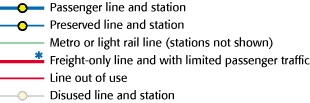
IntroductionView the latest version (3.9Mb PDF) - updated February 2026 The New Adlestrop Railway Atlas is a small-scale historical atlas of Britain's railways. It shows lines and stations currently open, together with those that have closed. The key is: ScopeThe map includes coverage of England, Wales and Scotland. It does not show:
The map may have mistakes - I make no claims to be a railway historian! But I will correct any that are drawn to my attention. The map is chiefly researched from historic maps and timetables. It is not intended to be a snapshot of any particular time. Many of the stations and lines will not have co-existed. Nonetheless, I hope you find it interesting and useful. Copyright and linkingThe atlas is © Richard Fairhurst 2001-2026. You are welcome to download a copy to your computer for personal use. Please contact me with any other usage enquiries. Please note that the data is purely illustrative (there is no georeferenced dataset behind it) so it's not suitable for incorporating into a GIS/data-driven mapping project. If you would like to link to the atlas, please link to this page at http://systemed.net/atlas/, not directly to the PDF file (which can and does move!). Thank you. ContactI would be very grateful to hear your comments, corrections and suggestions by email. Please:
Many thanks to the hundreds of people who have provided feedback or just encouragement. If you have difficulties viewing the map, please try another PDF viewer (e.g. Adobe Acrobat or Apple Preview). Some PDF viewers, such as the one built in to Firefox, are not capable of properly viewing a large file like this. Sorry, I can't give technical support on using PDFs. Richard Fairhurst · email richard@systemeD.net for corrections/updates having read the notes above Elsewhere
|